regression historical geography
Thirty-Nine, Then Twenty-Five
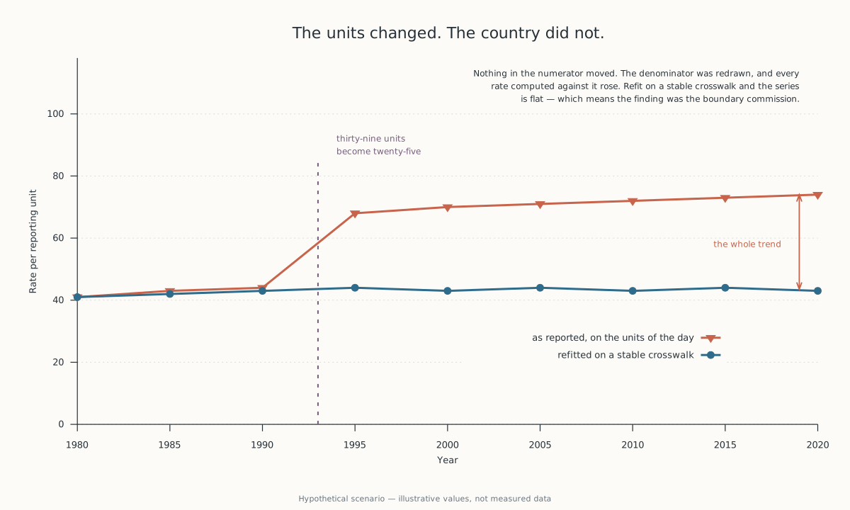
When the reporting unit changes, aggregation can manufacture a discontinuity even if every underlying place changed smoothly. Regression can quantify the apparent effect; historical geography says to repair the unit first.
- You are seeing
-
- A regional factor exposure jumps after territory recoding
- A panel regression shows a treatment effect at a jurisdictional reclassification
- A historical revenue series breaks when a subsidiary moves reporting regions
- A result disappears when the same observations are aggregated through another dated crosswalk
- The mechanism
- Regression turns coded units into fitted effects, while historical geography records how borders and state entities change over time; a coefficient can describe a reassigned denominator rather than a change experienced by any stable entity.
- The older apparatus
- Historical geography fixes dated entity mappings before comparison, and regression diagnostics distinguish a model's fitted result from the validity of the input coding.
- The false friend
- A real policy effect can coincide with a boundary change, but it persists when the analysis is run on entities unaffected by the reassignment.
- The discriminating test
- Refit on a stable crosswalk, on geographic intersections, and on native-period units; disappearance or reversal across codings indicates a boundary-created trend.
- On your own data
- Version every unit crosswalk, preserve native geography, and require treatment estimates to survive at least one stable-unit reconstruction before interpretation.
In 1866 the German Confederation stopped being what it had been since 1815. It had held 39 states under an Austrian presidency. Prussia’s war with Austria ended it, and the North German Confederation took its place.
On 18 January 1871 Bavaria, Württemberg, Baden and Hesse joined a new German Empire of 25 member states.
That is usually told as three steps toward a country. It is also a warning about any series labelled Germany.
The 1815 Confederation, the North German Confederation and the Empire cannot be one reporting unit until somebody decides what the word covers. The decision is often sensible. It is still a decision, and it is rarely written down.
A sum called Germany on either side of 1866 contains a different collection of places, firms, people and revenues. The jump between the two sums is real as arithmetic. Nobody inside either collection experienced it.
The name outlasted the denominator #
Italy runs the same sequence, with the dates close enough together to make the change look instantaneous. The Kingdom of Italy was proclaimed on 17 March 1861 out of Piedmont, the Two Sicilies, Tuscany, the smaller duchies and part of the Papal States. Venice arrived in 1866. Rome was taken in 1870 and made capital the year after.
An annual total labelled Italy across that decade is therefore not a measurement of one territory. It may still be a useful total. It will also manufacture an acceleration, because the later aggregate contains Venice and Rome and the earlier one does not.
The chart can be drawn with complete accuracy and still show the wrong event. Not a change in a place — the arrival of a place in the numerator.
Historical geography does not treat the modern outline as the fix for this. It treats the dated sequence of entities as the record. The North German Confederation, and the kingdom that did not yet have Venice, are political geographies in their own right rather than defective drafts of the later map.
That is the apparatus a panel needs before it is a panel: every observation mapped to the unit that existed when the observation was made.
What the coefficient cannot check #
Regression is good at putting a number on a contrast. A difference-in-differences model makes the contrast explicit, with an interaction between a jurisdiction and a period, and turns a state-by-time code into a fitted effect.
It cannot tell whether the state-by-time code describes a stable state.
Every diagnostic in the standard kit answers a question about the estimator rather than about the coding. Gauss-Markov concerns the errors. R-squared concerns the residual sum of squares, and cannot fall when a predictor is added, so a boundary-date indicator improves the fit whether it marks a mechanism or a filing change. Neither has any way to notice that a region acquired new members halfway through the input. The code can satisfy every arithmetic requirement and still merge observations that were never in the same place.
The old map decided the case #
In October 1983 Burkina Faso and Mali put their land border to the International Court of Justice by special agreement. The Chamber’s judgment of 22 December 1986 was reached from French colonial legislative and administrative texts, from maps, and from colonial effectivités — the evidence of who had actually been administering what. No new survey was commissioned. The old record was the operative one.
The principle is uti possidetis juris: a new state presumptively inherits the administrative boundary it held at independence. The colonial map is not scene-setting there. It decides which ground is in dispute.
A historical revenue file needs the same things kept: the native reporting assignment, its effective date, and the crosswalk used for every later reconstruction. Without them an analyst can produce a clean series only by silently swapping one entity for another.
The result will usually reproduce. The same silent rule reproduces it. Reproducibility is not identity.
The repair happens before the fit #
There are three defensible views of a changed geography and they answer different questions. Native-period units preserve what was reported at the time. A stable crosswalk reallocates everything onto one chosen geography. Geographic intersections keep only the ground that exists on both sides of the boundary.
None of the three is the true series. Each makes its denominator inspectable, which is all that is being asked of it.
The test is not whether one reconstruction gives the sign you wanted. It is whether sign, scale and inference survive all three. A result that vanishes or reverses is a property of the boundary rule. A result that persists among entities never reassigned is evidence of something that happened on the ground.
The map that records a new jurisdiction changes what a regression estimates.
The record that preserves the old one is what says whether the estimate refers to anything that stayed put.
Questions
Why did a regional exposure jump when none of the businesses changed?
A regional exposure can jump because the region contains a different set of businesses after a recoding, even when every business changes smoothly. Germany illustrates the problem: the German Confederation held 39 states from 1815 to 1866, while the empire proclaimed on 18 January 1871 comprised 25 member states. A series using the same label across both periods may compare two different denominators.
Can a regression mistake a jurisdictional reclassification for a treatment effect?
Yes. A regression fits the codes supplied to it, so a jurisdiction-by-period interaction can estimate the effect of a reclassification if the jurisdiction contains different entities after the boundary date. Ordinary least squares is BLUE only under stated assumptions about errors and a full-rank linear specification; it does not certify that a geographic unit means the same collection of places in every period.
What should happen when a subsidiary moves between reporting regions?
The native reporting geography and every dated crosswalk should be retained. A regional revenue break can then be reconstructed on the former assignment, the later assignment, and a stable intersection. Italy shows why the dates matter: the Kingdom of Italy was proclaimed on 17 March 1861, Venice was added in 1866, and Rome was captured in 1870 before becoming capital in 1871.
How can an analyst tell whether a border-created trend is real?
An analyst refits the result on native-period units, on a stable crosswalk, and on geographic intersections. A result that disappears or reverses across those codings is created by the boundary rule; a real effect remains among places unaffected by the reassignment. In the Burkina Faso/Mali dispute, the International Court of Justice's 22 December 1986 judgment weighed colonial administrative texts, maps, and effectivites because the dated boundary record was the issue.
Sources
- "Coefficient of determination," Wikipedia (used for R² formula referenced in `results`) · Wikimedia Foundation (tertiary, 2026-08-13)
- "Credit scoring," Wikipedia (logistic regression for default prediction, UK/Australia scorecard practice, FICO version count, median-score figures) · Wikimedia Foundation (tertiary, 2026-08-13)
- "Framingham Risk Score," Wikipedia (cohort origin, three revisions, risk-band thresholds and population distribution) · Wikimedia Foundation (tertiary, 2026-08-13)
- "Gauss–Markov theorem," Wikipedia (assumption list: linearity, exogeneity, homoscedasticity, no autocorrelation, full rank) · Wikimedia Foundation (tertiary, 2026-08-13)
- "Least squares," Wikipedia (loss function, normal equations) · Wikimedia Foundation (tertiary, 2026-08-13)
- "Longitude rewards," Wikipedia · Wikimedia Foundation (tertiary, 2026-08-13)
- "Meridian arc," Wikipedia · Wikimedia Foundation (tertiary, 2026-08-13)
- "Metre," Wikipedia · Wikimedia Foundation (tertiary, 2026-08-13)
- "Minimum wage," Wikipedia, Card and Krueger section (1992 New Jersey/Pennsylvania wage figures, difference-in-differences method, Neumark-Wascher 1996 reexamination, 2000 rebuttal) · Wikimedia Foundation (tertiary, 2026-08-13)
- "Piri Reis map," Wikipedia · Wikimedia Foundation (tertiary, 2026-08-13)
- "Unification of Germany," Wikipedia · Wikimedia Foundation (tertiary, 2026-08-13)
- "Unification of Italy," Wikipedia · Wikimedia Foundation (tertiary, 2026-08-13)
- "Uti possidetis," Wikipedia · Wikimedia Foundation (tertiary, 2026-08-13)
- "Variance inflation factor," Wikipedia (formula, VIF > 10 and VIF > 5 thresholds with citations to Kutner et al. and Sheather) · Wikimedia Foundation (tertiary, 2026-08-13)
- International Court of Justice, Case 69, Frontier Dispute (Burkina Faso/Mali) (primary, 2026-08-13)
- ORBIS: The Stanford Geospatial Network Model of the Roman World (primary, 2026-08-13)